|
Astronomy
Ein vereinfachtes Verfahren zur
Berechnung der Sonnenhöhe
Basics of Positional Astronomy The observer is located at the centre of his "celestial sphere" with zenith Z above his head and the horizon N-E-S-W. The Sun, Moon or any other celestial body can be identified by the two coordinates altitude h and azimuth alpha (horizontal coordinates). Altitude is the angular distance above the horizon (0 < h < 90°), and azimuth the angular distance, measured along the horizon, westwards from the south point S (in astronomy) or eastwards from the north point N in nautics (0 < alpha <360°). The daily movement of an object -
resulting from the rotation of the Earth on its axis -
starts when it rises
at (1). At (2) it passes across the observer's meridian NZS
(transit), and it sets at (3). Only fixed stars (constant declination) reach the greatest altitude above horizon (culmination) on the meridian. Details about the difference between transit and culmination
Please watch the Java applet Apparent Movement of a Star by Walter Fendt). The horizontal coordinates of an object depend on the location of the observer on the Earth (and on time). In astronomy equatorial coordinates are commonly used when giving the position of an object on the celestial sphere. The equatorial system is based on the celestial equator, which is the great circle obtained by projecting the Earth's equator on to the celestial sphere, the equatorial plane being perpendicular to the Earth's axis of rotation. 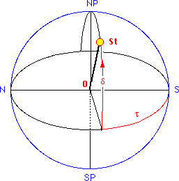
The first equatorial coordinate is declination delta,
measured in degrees north and south of the celestial
equator (N: 0° < delta < 90°, S: 0° > delta
> - 90°. The second coordinate, may be the hour angle tau,
measured along the equator from the meridian S-NP-N
of the observer to the hour circle SP-St-NP
of the star St. The hour angle corresponds to the
length of sidereal time elapsed since the body St last
made a transit of the meridian.
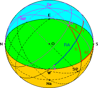 To convert equatorial coordinates hour angle (tau) and declination (delta) to horizontal coordinates azimuth (az) and altitude (h), the "nautical triangle" NP-Ze-St is used: NP-St = 90° - delta, Ze-St = 90° - h. From spherical trigonometry we get: tan az = (- sin tau) / (cos latitude tan delta - sin latitude cos tau) Example: The second equatorial coordinate may also
be right ascension
RA, measured in hours, minutes and seconds of time,
taking into account the rotation of the celestial
sphere once in 24 hours of sidereal time. The zero
point for right ascension is taken as the northern vernal equinox. 
Right ascension RA, hour angle tau and sidereal time theta are related by: tau = theta - RA |
2.
Conversion of date and time: local time to universal time UT
15 h CEST = 13 h UT convert time: Julian
Day of 1991/ 5/19 at 13
UT Julian day of 2000/01/01 at 12 UT number of Julian days since 2000/01/01
at 12 UT number of Julian centuries since
2000/01/01 at 12 UT JD = 2448396.04167 JD = 2451545.0 -3148.95833 2. Astronomical
algorithms: compute
ecliptic longitude of
the Sun apparent longitude latitude B is assumed to be zero
L = 58.06° convert ecliptic longitude to right ascension
RA and declination delta RA = 55.81° compute sidereal time (degree)
at Greenwich local sidereal time at longitude 10° E
local hour angle theta0 = 71.70° 3. Final results:
convert (tau, delta) to horizon coordinates
(h, az) of the observer (50° N, 10° E) The function
atan2(numerator,denominator) should be used to
avoid ambiguity. altitude angle: h = 53.4
° azimuth angle: az = 223.6° from N
compute the position of the Sun on
1991/05/19 at 15:00 CEST
Berechnung des Sonnenstandes
used by the algorithm for L
T = - 3148.95833/36525
= - 0.086213780
delta = 19.73
theta = theta0 + 10° = 81.70°
tau = theta - RA = 25.89°
azimuth angle: az = 223.6° - 180° = 43.6° from S